Mount Everest Routes: Southeast Ridge vs Northeast Ridge
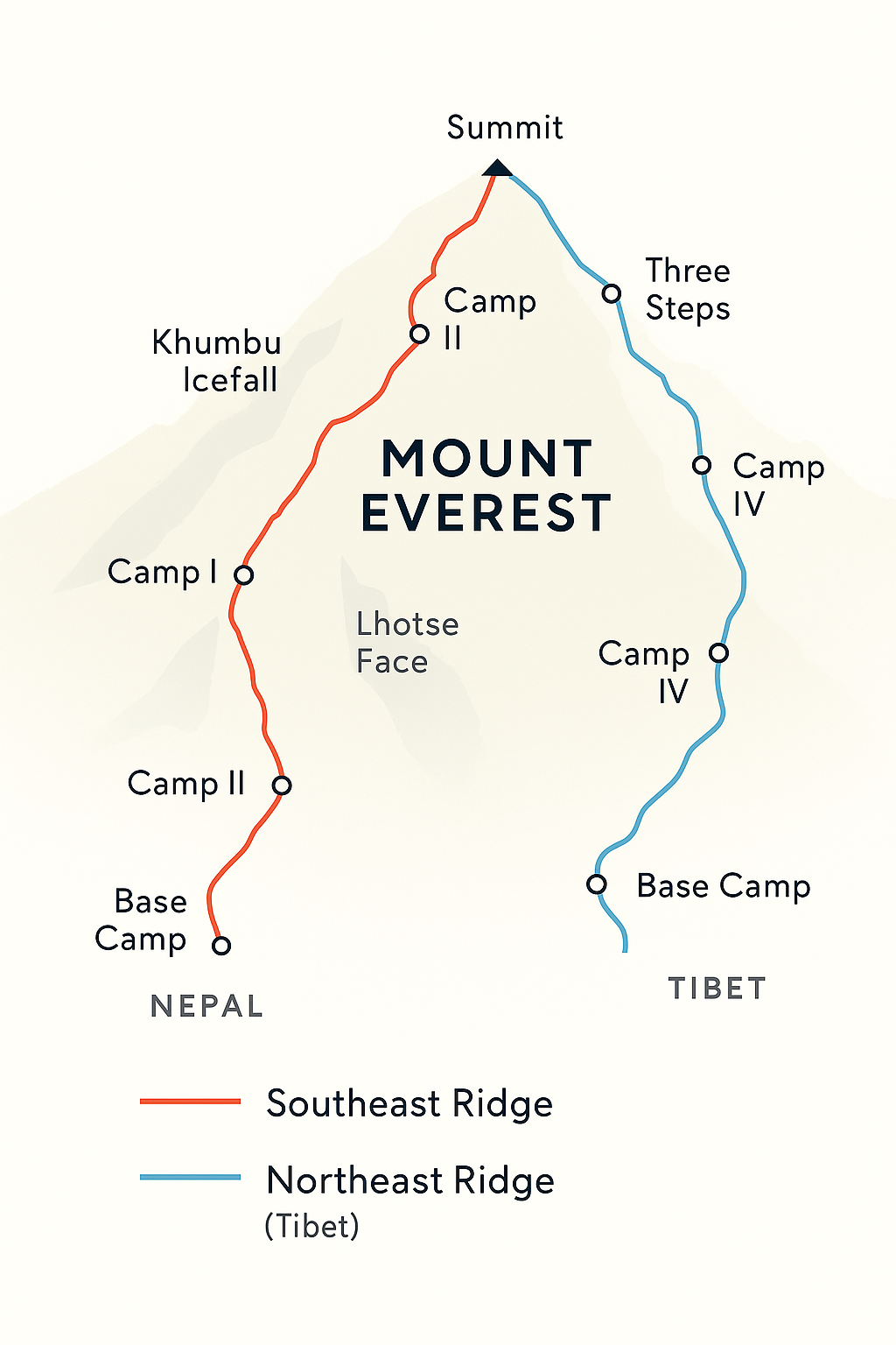
Choosing a route on Mount Everest is one of the most critical decisions an expedition can make. While over 20 routes have been established, more than 95% of all climbers use one of two main arteries to the summit: the Southeast Ridge from Nepal or the Northeast Ridge from Tibet. These two Everest climbing routes have distinct characters, challenges, and histories.
Understanding these distinctions, from the perilous Khumbu Icefall in the south to the windswept northern ridges, is crucial when planning a successful and safe ascent of the world’s highest peak.
The Southeast Ridge (Nepal Route)
The Mount Everest Southeast Ridge route is the “classic” way to the summit. It was pioneered by the 1952 Swiss expedition and famously completed by Tenzing Norgay and Edmund Hillary in 1953. Originating from the Nepali side of the mountain, this route is considered the more popular of the two main options.
Key Sections of the South Col Route
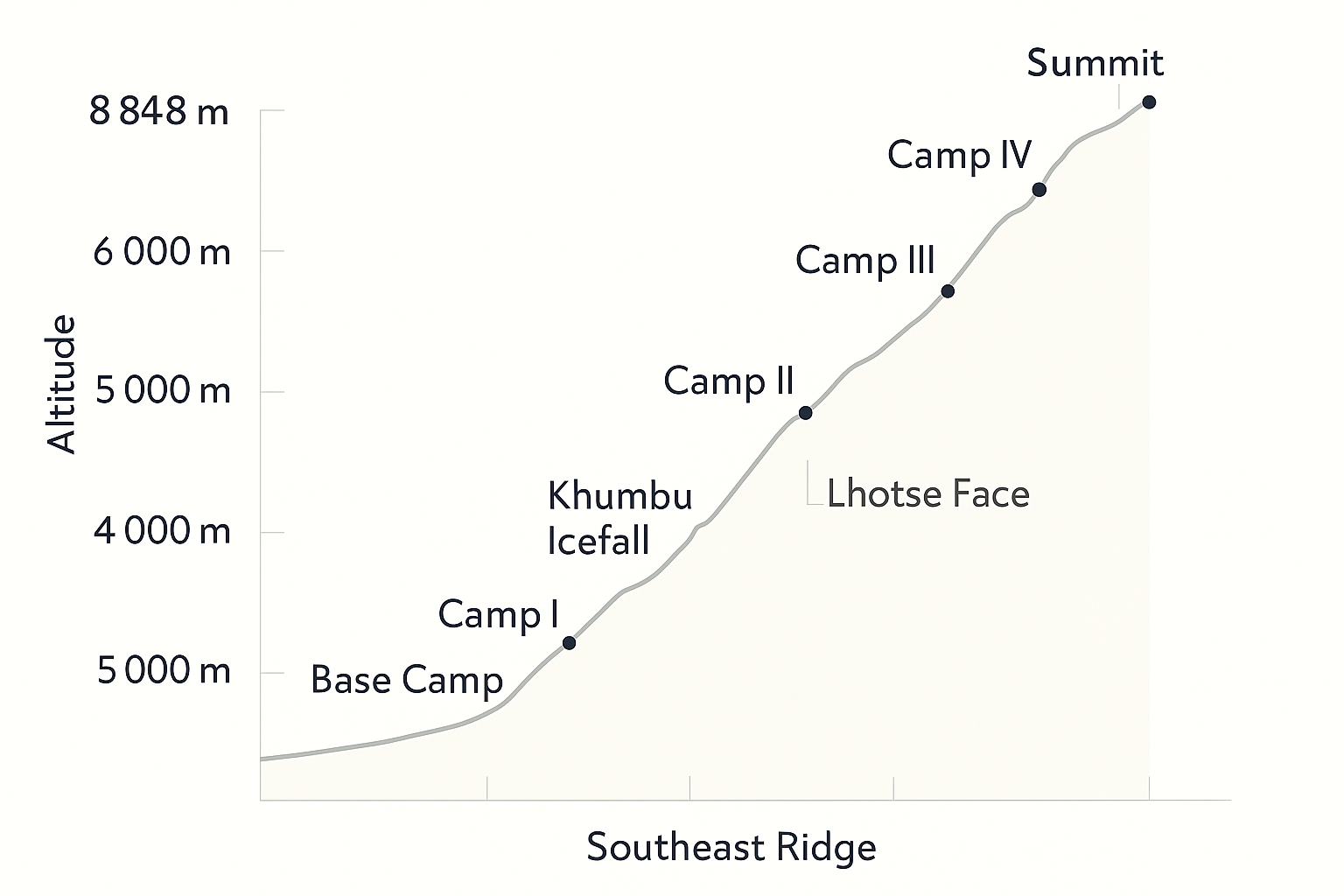
The journey from Everest Base Camp to the summit via the south is a climb through distinct, legendary sections. It begins at Base Camp (5,364 m) and ascends through the following major features:
- The Khumbu Icefall: An unavoidable and highly dangerous maze of shifting glaciers and seracs between Base Camp and Camp I.
- The Western Cwm: This relatively flat, glacial valley can become extremely hot due to reflected sunlight.
- The Lhotse Face: A steep, icy wall leading up to Camp III. Fixed ropes are used by climbers to ascend this section.
- The South Col: A windswept saddle between Everest and Lhotse where Camp IV, the final camp, is located. This is the start of the Death Zone Everest.
- The Summit Ridge: The final push involves ascending past the Balcony, the South Summit, and the site of the former Hillary Step route.
Pros: The route benefits from extensive infrastructure, experienced Sherpa support (especially for fixing ropes in the icefall), and easier access from Kathmandu.
Cons: The primary drawback is the objective danger of the Khumbu Icefall. This route is also often crowded, frequently leading to bottlenecks at crucial sections.
For a detailed breakdown, read our complete guide to the Southeast Ridge Route.
The Northeast Ridge (Tibet Route)
The Mount Everest Northeast Ridge route was the focus of the early British expeditions in the 1920s and 1930s. Accessible from Tibet, this route possesses historical significance and offers a distinct set of challenges. It is typically regarded as the slightly more technical climb of the two main routes.
Key Sections of the North Col Route
The ascent begins from Advanced Base Camp (ABC) at 6,400 m, a point higher than the south side’s Base Camp. Key sections include:
- The North Col: A steep climb up the East Rongbuk Glacier leads to Camp I on the North Col, a large snowy saddle.
- The North Ridge: A long, exposed, and often windy ridge leading from the North Col to Camps II and III.
- The Three Steps: Three distinct rock steps on the final summit ridge. The Second Step is the most famous, featuring a ladder placed by a Chinese team in 1975 to overcome a sheer rock wall.
- The Summit Pyramid: The final section above the Third Step is a steep, triangular snow slope leading directly to the summit.
Pros: The biggest advantage is avoiding the Khumbu Icefall. Permits can sometimes be cheaper (though this varies), and the route allows for a drive-up to Base Camp.
Cons: The summit day is longer, and the route faces increased exposure to harsh winds. Prolonged exposure to extreme altitudes heightens the risk of cold-related injuries and altitude sickness. Access can be restricted due to Chinese political regulations.
For more details, explore our complete guide to the Northeast Ridge Route.
Comparing Southeast vs Northeast Routes
The Everest Southeast vs Northeast route comparison is a key consideration for any aspiring climber. The choice depends on risk tolerance, budget, and climbing style. Here is a direct comparison of the key factors:
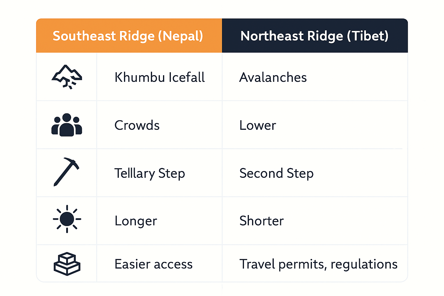
- Success Rates: Historically, the success rates on both routes have become comparable in the modern era, hovering around 60-70% for climbers who leave the final camp for the summit. However, this varies significantly by year and operator.
- Mortality Rates: The overall mortality rates are statistically similar. The south side sees more deaths related to objective hazards like avalanches in the Icefall, while the north has more deaths attributed to falls and altitude-related issues on the long ridges.
- Costs & Logistics: The permit costs in Nepal are generally higher than in China. However, overall expedition costs can be similar when factoring in logistics, rope-fixing fees, and Sherpa support.
- Accessibility: The Nepal side is politically more stable for access. The Chinese government can, and has previously, closed the Tibetan side to foreigners with little warning.
While Everest’s routes have serious, descriptive names like “Southeast Ridge” and “North Col,” climbing culture worldwide has embraced creative and hilarious route naming traditions, explore the funniest examples from crags around the globe.
Other Notable Routes
While the two main ridges see the most traffic, they are far from the only ways up Everest. Expert alpinists have pioneered routes up some of the mountain’s most challenging faces; however, these are rarely attempted.
- West Ridge: First ascended in 1963 by Americans Tom Hornbein and Willi Unsoeld, this is a long and highly committing route with extreme difficulty.
- Kangshung Face: The massive East Face is considered the most dangerous side of Everest. First climbed in 1983 by an American expedition, it is threatened by constant avalanches and is rarely considered by modern climbers.
Camp-by-Camp Overview
This camp-by-camp guide for Everest provides a snapshot of the typical progression on the two main routes. Altitudes are approximate and can vary slightly.
| Location | Southeast Ridge (Nepal) Altitude | Northeast Ridge (Tibet) Altitude | Key Features |
|---|---|---|---|
| Base Camp | 5,364 m / 17,598 ft | 5,180 m / 16,990 ft | Expedition hub; trek-in access (Nepal), vehicle access (Tibet). |
| Camp I | 6,050 m / 19,900 ft | 7,010 m / 23,000 ft (North Col) | Above Khumbu Icefall (Nepal); On the North Col (Tibet). |
| Camp II | 6,400 m / 21,000 ft | 7,500 m / 24,750 ft | Advanced Base Camp in Western Cwm (Nepal); On the North Ridge (Tibet). |
| Camp III | 7,200 m / 23,700 ft | 7,900 m / 25,900 ft | On the Lhotse Face (Nepal); High on the North Ridge (Tibet). |
| Camp IV | 7,950 m / 26,000 ft (South Col) | 8,300 m / 27,300 ft | Final camp in the Death Zone; launchpad for the summit. |
| Summit | 8,848.86 m / 29,031.7 ft | The top of the world. | |
Notable Hazards & Features
Each route has iconic sections that define its character and present unique risks. These features are widely recognized in mountaineering lore.
The Khumbu Icefall
The Khumbu Icefall dangers cannot be overstated. This constantly shifting river of ice presents a chaotic landscape of deep crevasses and towering seracs that may collapse without warning. The route through it is maintained by a dedicated team of Sherpas known as the “Icefall Doctors,” who use ladders and fixed ropes. The crucial role of the Sherpa culture and expertise is most visible here.
The Hillary Step (Before and After 2015)
The famous Hillary Step before and after the 2015 earthquake is a topic of much discussion. Once a formidable rock climb that created significant bottlenecks, its collapse has transformed it into a rugged snow-and-rock slope. While technically easier, some guides argue the new feature is less secure, as there are fewer solid rock anchors for fixed ropes.
Timeline of a Summit Push
An Everest expedition is a marathon, not a sprint. This process is meticulously managed to aid acclimatization before the final ascent.
- Acclimatization Rotations: Over several weeks, climbers make multiple trips up to higher camps (e.g., from Base Camp to Camp III and back down) to allow their bodies to adapt to the altitude. This process is vital for reducing the risk of acute mountain sickness.
- Waiting for the Summit Window: In late May, the jet stream that blasts the summit often moves north, creating a brief period of calmer weather. Expeditions monitor forecasts intently, waiting for this “window” to launch their summit bid.
- The Final Push: Once a window is identified, teams move up from Base Camp, progressing through the higher camps over 4-6 days to position themselves at the final camp for the summit attempt. The entire process, from arrival to departure, takes about two months.
Key Takeaways
- The two main Everest climbing routes, the Southeast Ridge and Northeast Ridge, offer very different experiences and challenges.
- The Southeast (Nepal) route is defined by the objective danger of the Khumbu Icefall but has better infrastructure and a slightly shorter summit day.
- The Northeast (Tibet) route avoids the Icefall but features a longer, colder, and more exposed climb at extreme altitude.
- The choice of route depends on an individual’s climbing experience, budget, risk tolerance, and the geopolitical situation. Both are extremely demanding and dangerous undertakings.
Frequently Asked Questions (FAQ)
Which is harder: Southeast or Northeast route on Everest?
Both routes are extremely difficult. The Southeast Ridge (Nepal) is technically challenged by the dangerous Khumbu Icefall but is generally shorter. The Northeast Ridge (Tibet) avoids the Icefall but involves more time spent at extreme altitude and is exposed to harsher winds, making the summit day longer and colder. The ‘harder’ route often depends on a climber’s strengths and tolerance for different types of risk.
How many routes lead to the Everest summit?
There are over 20 established routes to the summit of Mount Everest, but the vast majority of climbers (over 95%) use one of two main routes: the Southeast Ridge from Nepal or the Northeast Ridge from Tibet. Other routes, like the West Ridge or Kangshung Face, are far more technical and climbed very rarely.
What is the Hillary Step and what happened to it?
The famous Hillary Step before and after the 2015 earthquake is a topic of much discussion. Once a formidable rock climb that created significant bottlenecks, its collapse has transformed it into a rugged snow-and-rock slope. While technically easier, some guides argue the new feature is less secure, as there are fewer solid rock anchors for fixed ropes.
How long does it take to climb Everest from Base Camp?
The entire expedition, from arriving in Kathmandu to leaving, typically takes 6 to 8 weeks. This includes the trek to Base Camp, several weeks of acclimatization rotations up and down the mountain, and waiting for a suitable ‘summit window’ of good weather. The actual summit push from Base Camp takes about 4-6 days.
Daniel Whitaker is a mountain journalist and lifelong climber with over 15 years of experience in the European Alps and the Andes. Although he has not yet attempted Mount Everest, he has summited several 6,000-meter peaks in South America and multiple classic alpine routes in the Mont Blanc massif. Daniel specializes in writing about the culture, history, and psychology of mountaineering. His work combines first-hand mountaineering experience with extensive research on Himalayan expeditions, making him an engaging guide to Everest’s enduring myths, records, and inspirational quotes.